|
The
Chartiers Greenway
will connect over a quarter million residents in the Chartiers
Creek Watershed with recreational outdoor activities.
An important
wildlife corridor, it would provide 48 communities with a
continuous natural green and blue recreational thread.
|

|
|
GREENWAY |
GOALS
|
LAND USE |
WATER |
BIOLOGY |
CULTURAL
|
|
|
Water
Quality
is impaired by pollution that includes abandoned mine drainage,
sewage, excess nutrients and urbanization. The valley has been
mined for coal since 1760, while new residential and commercial
development has created flooding and landslides.
|
 |
|
ABANDONED
MINE DRAINAGE) |
FLOODS |
HYDROLOGY |
WATER
QUALITY
amd
chemistry |
amd discharge |amd
scope |
mine map creation |
gladden
| wingfield
| upper
|
middle |
lower |restorable
segments |
high |
medium |
low |
floodwater
| nature
| development
| bridges
|
amd
| biology
| storm
plan |
sewage
|
|
|
Land
should be left undeveloped on environmentally sensitive steep
wooded hillsides and floodplain wetlands, for both environmental
and economic reasons. So far only a fraction of
acreage in this vital green corridor by Chartiers Creek and its
tributaries has been protected.
|
 |
|
LAND
|
CONSERVATION
Boyce-Mayview |
Wingfield Pines |
Kane
Woods |
Neville Woods
Carnegie
| Idlewood
|
Crafton
| Ingram
| Windgap
|
Sheraden
Park |
Riverfront |
|
|
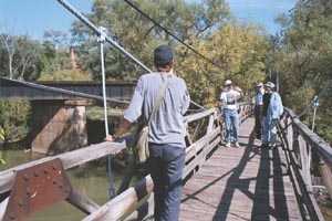
Trails
on
the greenway's hillsides, floodplain, wetlands and waterways
need to be linked together to improve access and enjoyment of
natural resources. Organized and spontaneous canoe
outings are becoming more frequent year round on Chartiers
Creek, the water trail.
|
 |
|
CANOE
| HIKE
| RECREATION
why
| what
| how
| upper
watershed
Boyce Mayview |
Chartiers
| Robinson
Run
| Kane
|
|
|
Think
Globally - Act Locally
by joining your local conservation group. Participate in
outdoor recreation. Hike the Chartiers Greenway, canoe down
Chartiers Creek, be environmental stewards of your Chartiers
Watershed. Its your backyard.
|
 |
|
ENVIRONMENT
| GREEN
CONSUMER |
ENERGY | ECOLOGY
| LINKS |
