CANOE CHARTIERS CREEK
|
||||||||
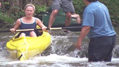
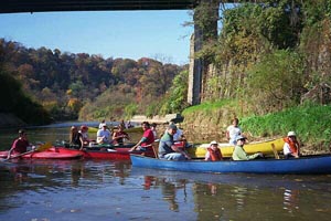
Admit it, you have looked at Chartiers Creek and wondered, "Could I canoe that?" Sure, why not. There are a lot of sections that cannot be seen from the road and who knows what is around the bend? Who knew that our first trip in May 2000, with 23 voyagers (plus one dog), would end up being an annual event for several years? |
|
|||||||
 |
||||||||
|
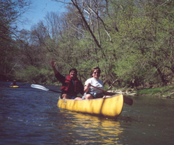
Float beneath quaint bridges that span stretches of tree-lined banks as you navigate on Chartiers Creek toward the Ohio River. Churn your way through exciting rapids below Canonsburg one moment, then round the bend to discover an immense great blue heron rookery nested across 5 large sycamores.. |
||||||||
The fantastic scenery on the downstream trip is reminiscent of a wilderness area in a national forest. Stop off and explore the Conservation Area at Allegheny Land Trust's Wingfield Pines or Upper St. Clair's Mayview Wetlands. Indulge in a journey of contrasts as primordial wilderness snakes through an urban setting. Spring wildflowers splash steeply forested hillsides while towns perch on creek banks overhead. |
 |
|||||||
 |
Only when Chartiers Creek meanders through one of Valley Brook Golf Club's fairways and the golfers warn 'fore' as they hit their tee shots over our heads, did the realization occur that this creek is located only a few hundred yards from shopping centers and I-79 in a heavily developed urban area. |
|||||||
| Experience the journey as an early explorer may have. You may even get an encore performance by the spring peeper frogs chirping from nearby wetlands. | ||||||||
|
. For info on upcoming canoe trips: CanoeChartiers@verizon.net |
||||||||
|
|
||||||||
Shorter Trips |
||||||||
|
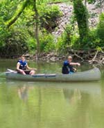
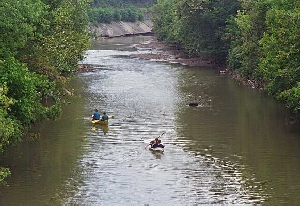
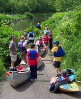
The maps below highlight various short tours on Chartiers Creek. Each is shown as a blue water route between the red dots. Launch access and basic trip logistics are covered on this page. The upper portion of the creek, above Bridgeville, should be run in the spring or during high water. The lower portion is year round. These trips are from around one to three hours, depending upon water level. Our zany adventures on these one, two and "three" hour tours are chronicled in OUTINGS on the top navigation bar (links to the Recreation Page of the Lower Chartiers Watershed Council's website) so that all water enthusiasts can gain from our learning curve. |
||||||||
Run Upper Chartiers CreekExperience thrilling rapids, rather than the gravel bars that will ground your boat. Consider running the upper part of Chartiers Creek when the water level is high. Make your trip a canoe float, rather than a canoe "hike." Most often high water occurs in the spring or just after a heavy rain. Creek levels can rise and fall very quickly. |
|
|||||||
|
|
|||||||
|
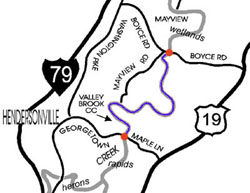
Check the gauge to determine water level. The most navigable portion of the upper runs from Canonsburg to Bridgeville. In spring or early summer, or anytime after a rain, shorter trips (outings) include Canonsburg to the Heron Rookery, Valley Brook Golf Course to Mayview Wetlands (map), or Mayview to Bridgeville. |
||||||||
 |
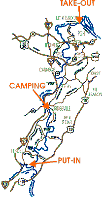
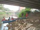
Float Lower Chartiers CreekA day trip down the lower part of Chartiers Creek starts at the division between old and new (Fulton Project) creek channels near Heidelberg and ends at McKees Rocks. A put-in with good launch and parking can be found at the ChemTech parking lot just off Washington Pike (Rt 50). |
|||||||
|
Take-out at the parking lot by Crivelli Chevrolet in McKees Rocks is rocky, but there is a convenient boat ramp on the Ohio just past the confluence with Chartiers Creek. Scale Bruno's Island while you're at it. |
||||||||
|
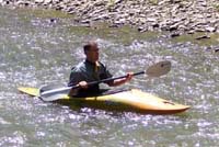
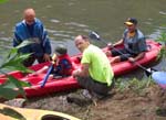
You can take a shorter four hour downstream trip from Carnegie to McKees Rocks. Carnegie is on our list of canoe launch sites to get improved access. Carnegie's Art & Heritage Festival features afternoon canoe rides in the pool between Carnegie's Main Street bridge and the Mansfield Avenue bridge, shown at right: |
 |
|||||||
 |
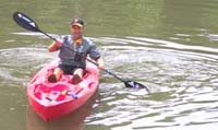
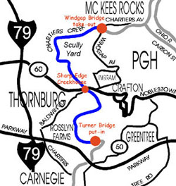
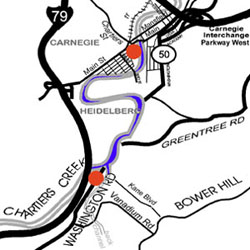
A good halfway break on the Carnegie to McKees Rocks trip is at the Sharp Edge Creekhouse by the Thornburg Bridge (pictured left). This is also a good put-in or take-out point for shorter floats down the Chartiers. Want a shorter excursion? Do the run from Heidelberg to Carnegie, or Carnegie to Sharp Edge, or Sharp Edge to Windgap. (see outings ) The new ramp constructed by the Army Corps during the flood control restoration makes a good put-in/take out point in Heidelberg. Carnegie put-in/take out is under the Main Street bridge. There is a potential put-in/take out in Windgap near the Industrial highway. |
|||||||
 |
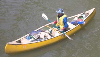
The past few summers have seen several impromptu excursions. Many of these started after work as a way to relax in the warm summer evenings. After a few midnight tours, canoeing by the light of the moon, or more often, by the light from billboards, we adjusted the distances to reflect what can be canoed at low water levels to get from put-in to take-out by sunset. |
 |
||||||
|
Our zany adventures on these one, two and "three" hour tours are chronicled for all water enthusiasts to gain from our learning curve. The maps above show one hour tours on the lower creek between the red dots - The old Turner Bridge abutment (the bridge is now gone) to the Sharp Edge, or the Sharp Edge to Windgap Bridge (map on left). Or do the run from ChemTech to Carnegie (map on right) or Carnegie to the Sharp Edge. The trips, first conducted in the summer and fall of 2005, with photos and write-ups by Bernadette Kazmarski, Robin Anthony and the late John Hamm, are posted on the Recreation Page of the Lower Chartiers Watershed Council's website. You can view them here via our convenient outings link, but please visit the Lower Chartiers Watershed Council's site for info on longer trips, including the watershed's two-day canoe sojourn, other recreational activities in the watershed, projects, funding, watershed happenings and all things Chartiers. For info on upcoming canoe trips: CanoeChartiers@verizon.net |
||||||||
|
|
||||||||
Access & Water Quality |
 |
|||||||
|
So, you want to float Chartiers? Where are you going to put your boat in and take out? Where can you park your up/down-stream shuttle vehicles? There are no gentle-sloping launches or take out ramps. Public waterways like Chartiers Creek deserve to be safe and accessible for public recreation. To improve access, there is now grant money available to build canoe launches along the Chartiers Creek. |
||||||||
 |
 |
However, these improvements have not yet been made, so most access points will still be rocky, muddy, steep and slippery. You may need a machete beforehand or a poison-ivy potion afterwards. Many of the best access points are on private land, so make sure to get owner permission before you trespass their property. |
||||||
|
Every creek, river and lake has beauty in its natural state. It is hard to understand that questionable water quality lurks in the flow. These waters need to be preserved and restored for healthy habitat and passive recreation. |
||||||||
|
Watching water flow hypnotically affects us all. You don't get that experience watching water run through a cement culvert or where homes, businesses and industry choke the banks with fences and parking lots. Undeveloped creek banks should remain within a 100 feet or more of a waterway. Having desirable, nearby recreational opportunities, like those afforded by Chartiers Creek, not only makes good environmental sense, it spells economic opportunity for this region as well. |
 |
|||||||
|
|
||||||||
A Creek for All Seasons |
||||||||
|
||||||||
|
|
||||||||